Key Developments in the History of
Arch Dams
|
The Roman Empire
|
|
Vallon de Baume
It is rather astonishing that the Romans only sparcely applied the arch in dam
constructions, a design otherwise so masterfully employed in their buildings and bridges.
One of the few true arch dams built by the Romans was located in the Vallon de Baume, France
in order to supply the nearby city with water. The dam was 12 m high and 18 m long and
curved with a radius of about 14 m and a central angle of 73o. It consisited
of two masonry walls, 1.3 m wide on the upstream and 1.0 m on the downstream side, with an
intermediate earth core 1.6 m wide.
|
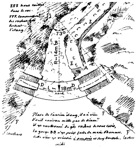
The Vallon de Baume Dam
sketch from Schnitter
courtesy of
A.A. Balkema (#)
|
|
Monte Novo
Another true arch dam was found at Monte Novo, Portugal. Unfortuantely, it was
recently submerged by a modern reservoir. As a result, it is undetermined whether or
not the dam was built by the Romans. However, who else but the Romans could have built
such a sophisticated structure? It was 5.7 m high and 52 m long, including the wing
walls at both ends. The middle part was curved with a radius of 19 m and a central
angle of about 90o. The dam was built of blocks of shist laid horizontally
in lime mortar. The key feature of the Monte Novo dam was that the curved part at both ends passed into the
wing walls without any abutment blocks to absorb the horizontal arch thrusts. Apparently the
builders of the Monte Novo dam did not entirely rely on their bold design because two buttresses
were added to the downstream face. They also provided two outlets which released water to drive
mills located downstream.
|
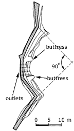
The Monte Novo Dam
sketch from Schnitter
courtesy of
A.A. Balkema (#)
|
|
The Mystery of Dara
Most interesting is, however, the dam built near Dara, Turkey. Procopius of Caesarea
(AD 490-562) stated that Chryses of Alexandria,
did not build this barrier in a straight line, but in the form of a crescent, in order that
its arch, which was turned against the stream of the water, might be able to better resist
its violence. The upper and lower parts of this barrier are pierced with apertures, so that,
when the river suddenly rises in flood, it is forced to stop there and to flow no further with
the entire weight of its stream, but passing in small quantities through the aperatures, it
gradually diminishes in violence and power....
This statement shows that the Roman engineers understood the principle of arch dams and
flood retention basins. However, recent preliminary surveys found no trace of the arch
dam--only the remains of two gravity wing walls. Nevertheless, in the 70 m wide gap between
the wing walls there might have been a slightly curved dam about 5 m high.
|
Mongolian Arch Dams in Iran
Kebar and Kurit
The Mongolians built the first arch dams since the Romans. The earliest one was built
around 1300 near Kebar, Iran. The Kebar dam was 26 m high, 55 m long, and was curved
with a radius of 35 m and a central angle of only 40o. The arch did not abut
against the canyon walls, instead it passed on both sides into straight wing walls like
the Monte Novo dam. |
|
The second Mongolian arch dam was built around 1350 in Kurit, Iran. The Kurit dam is
especially remarkable for its extraordinary height of 60 m. After increasing the height
by 4 m in 1850, the Kurit dam was to remain the world's highest dam until early in the
20th century. The dam was built in a very narrow canyon and its crest length reached
only 44% of the height. It therefore remained erect, despite the fact that a large segment
of lower half of the vertical downstream face broke away.
|
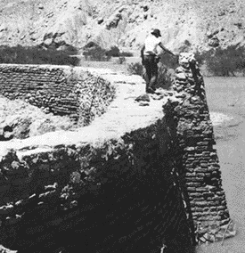
The Kurit Dam
photo from Schnitter
courtesy of
A.A. Balkema (#)
|
Postmedieval Europe
Elche
The first true arch dam in Europe since the Roman times was built from 1632 to 1640 near Elche,
Spain. The Elche dam's main arch was 75 m long at the crest and was curved to a radius of
62 m with a central angle of 70o. The rather slim cross section of the dam was
completely adequate according to modern computer analysis. |
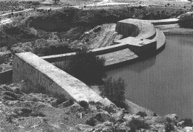
The Elche Dam
photo from Schnitter
courtesy of
A.A. Balkema (#)
|
|
The Elche dam was designed by Joanes del Temple who adapted it masterfully to the
peculiarites of the site with one flank consisting of a low ridge. He let the arch
across the main gorge end in an artificial abutment block on the ridge, from where a
long wing wall completed the structure. Also, the other end of the arch crest abutted
not against rock, but against a wing wall directed upstream.
Thus, in the Elche dam's uppermost part, the arch thrusts did not have much support and were
therefore deflected downwards. This had been the case to an even greater extent at the
Mongolian Kebar dam and the Monte Novo dam.
|
The Evolution of Modern Arch Dams
Variable Radius
In 1914, the construction of the first variable radius arch dam was completed at
Salmon creek, Alaska. The shape of the dam became the standard for variable radius type
arch dams. The upstream bulging served to off-set the undercutting by the stronger curved
lower arches near the abutments while the pronounced downstream toe reduced the tensile
stresses at the upstream heel. The full realization of the new design was made posible
by building the dam entirely out of concrete. |
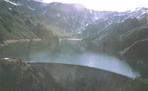
The Salmon Creek Dam
photo courtesy of Ram P. Sharma
Morrison Knudsen Corp. (#)
|
|
The technical as well as economic advantages of
this design were immediately recognized. It rapidly gained popularity in the western USA and
elsewhere. Although it never replaced the regular arch dam completely, the variable radius
arch design was to prove especially suitable for high and large dams. |
Radical Designs
A few dams have been experiments in themselves. The La Gage dam in France and the Tolla Dam
in Corsica were both made exceedingly thin in order to provide a full-scale check on the
validity of theoretical analyses when applied to dams approaching the ultimate degree of
slenderness. The two dams are a complete success and have been shown to posses adequate
margins of safety. Whether or not such thin dams are psychologically justifiable is
another matter. |
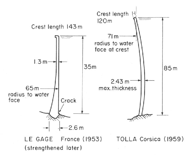
The Tolla and Le Gage Dams
sketch from Thomas
|
The Double-Curved Arch Dam
"When it became noised abroad that a dam 90 ft. high and but 8 ft. thick at
the base was to be built only two miles above Ithaca, to form a lake of 60 acres
area, many people immediately saw visions of a Johnstown flood, and protests began
to appear in public prints."
But the dam still holds strong in 1999. It is curved both along its crest and
along the height.
ref: Williams, 1904
|
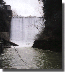
The Ithaca Arch Dam
photo courtesy of
M.V. Polaha (#)
|
|
The 1960's brought a revival of arch dam construction in the USA,
particularly so after the adoption of the double-curvature design by the
USBR for some of its most important structures like, for example,
143 m high Morrow point dam built in 1968. Furthermore, arch dams
became established in such regions of great dam building activity as
the Iberian Peninsula, Japan, and the former Soviet Union (the highest
is the Inguri dam of 1980 in Georgia at 272 m and longest at 680 m and
most concrete at 3,960,000 m3). |
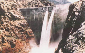
The Morrow Point Dam
photo courtesy of
Bureau of
Reclamation (#)
|
|
At the same time, both the designs and
construction techniques reached considerable uniformity. But in spite
of the high perfection and productivity attained in their construction,
arch dams lost ground in the last few decades. Similarly to the classical
gravity dams, they were outranked by embankment dams, even in the field
of very high structures. |
|
Epilogue: A Tragic Display of Strength
The great reserves of strength inherent in an arch dam were dramatically displayed
in 1963 when the reservoir behind Vaiont Dam in Italy was virtually destroyed by a
landslide. Vaiont, at that time the second highest dam in the world, was built
across a narrow gorge on limestone foundations so that the crest 858 feet above
the valley bottom was only 623 feet in length. Some large-scale instability in
the mountainside above the reservoir had been observed earlier by the engineers
during filling. |
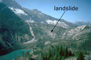
The Vaiont Landslide
photo from Kingston University School of Civil
Engineering (#)
|
|
They were allowed to proceed very slowly, and three years later,
on Oct. 9, 1963, with filling still incomplete, about 314 million cubic yards of
soil and rock slid down into the reservoir, sending a tremendous volume of water to a
height of 853 feet on the opposite side of the valley. The flood overtopped the dam to
a depth of 328 feet and surged down the valley, causing a major tragedy, the destruction
of several villages with a large loss of life. Yet, only superficial damage was caused to
the dam, which, at its crest, is about 11.2 feet thick. |
 
|


