Kolnbrein Background
|
|
dam type: thin double curvature concrete arch buttress
purpose: hydroelectric power, flood control, and water supply
height: 656 ft (200 m)
width at foundation: 121.4 ft (37 m)
length of crest: 2054 ft (626 m)
storage capacity: 162,000 acre-ft. |
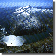
photo courtesy of Erich Wagner
|
| Kolnbrein is part of the Malta hydro power complex, the most
powerful in Austria.
|
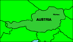 |
location: Carinthia, Austria, in the Hohe Tauern Mountain range
river: Malta river
foundation & abutments: granitic gneiss on one side, schistose gneiss
on the other, and highly schistose gneiss at the bottom of the valley
|
- While most arch dams are built in V-shaped valleys, Kolnbrein was built in a
U-shaped valley and has a longer crest than most.
- As is done for many dams, grout curtain was constructed in the
foundation near the upstream side. A grout curtain is a thin wall of
a strong cement-like material. The curtain sits as a wall in the
foundation under the dam, keeping water from seeping under the dam
and creating uplift pressure.
|
|
owned by: Osterreichische Draukraftwerke AG
construction start date: 1973
construction end date: 1979
volume of concrete in the dam: 2,094,941 yd3 (1,600,000
m3) (this is considerably less than a )
first partial reservoir filling: 1978
second partial reservoir filling:
1979
|
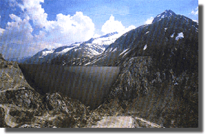
Empty reservoir
photo courtesy of Erich Wagner
|
|
Filling had to be stopped 39.4 ft (12 m) below top reservoir level
because uplift and seepage occurred. |


|